Adventure #4a: Brookside, Summitville, & Nirvana

We headed out bright and somewhat early on September 2, 2017 from Big Rapids, hoping to find some interesting spots on Highway 10.  There were several indicated on the map we accessed from http://www.ghosttowns.com, and we found one that wasn’t included on there–Nirvana (which is apparently pronounced by the locals such that the “van” rhymes with “can” rather than “con”–apologies to Kurt Cobain).

Brookside was more or less nonexistent; there was nothing even to photograph.  Summitville was similarly empty, except for a long, winding road that included several sandy hills:

IMG_20170902_114528959

We drove down the road a ways, noting that only a few people were there apparently camping, and there were a couple of residences down a private drive–nothing visible from the road.  So we headed back to M-10 and proceeded west.  That’s when we found Nirvana.  And by “found,” I mean there was a sign that said “Nirvana” (which we missed the first time we passed it) and a boarded-up church.

IMG_20170902_115256264_HDR

We thought there might be a cemetery near the church, so we hunted around on Google Maps and finally found it–Cherry Valley Township Cemetery, off of Knight Rd.

This was one of the odder cemeteries we’ve ever visited; for one, there were lots of missing stones, stones with missing dates (when the person is obviously no longer living), or strange stand-ins for stones, like this cinder block:

IMG_20170902_120718075.jpg

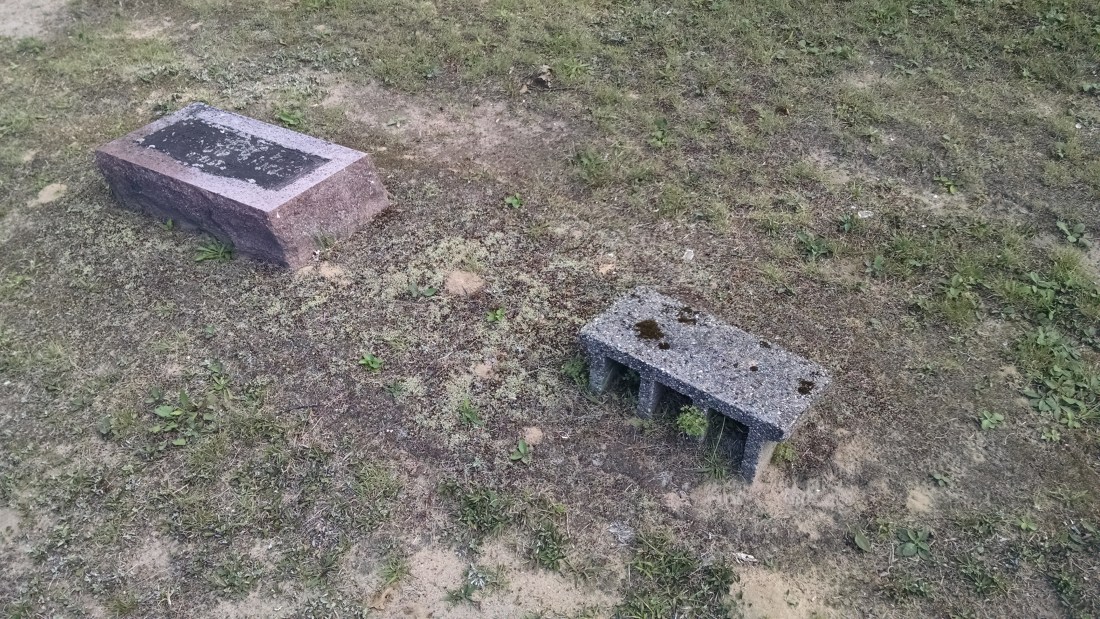
Or a basket of fake flowers with a nametag in it.  Or just a plain wooden cross with no name on it.  That sort of thing.

There were many World War I veterans in this cemetery; we assume that’s when the area was still thriving.  There were some newer interments, but mostly older ones.  Family names like Fray and Avery.

This slideshow requires JavaScript.

Then something really remarkable happened.  As we were getting ready to leave, an older couple came into the cemetery to tend a plot of graves.  They were very friendly, pulling up behind our car (since there’s only one drive, we asked if they needed us to move, but they cheerfully declined).  After a few minutes, they realized we weren’t there for any specific person and asked us, not in any kind of suspicious way, what we were up to.  When we told them, the older man got really excited and asked, “Have you ever heard of Andy Horujko?”  When we said we had not, he led us over to a grave and started to tell us quite the story.

IMG_20170902_124214174.jpg

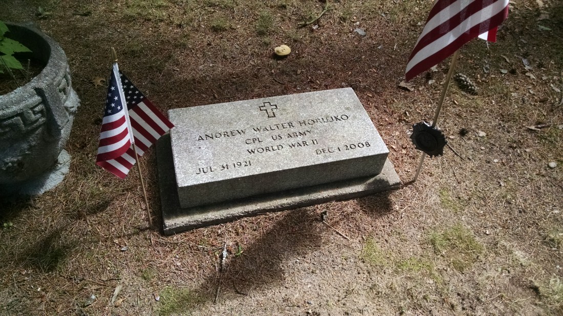
Andrew (Andy) Horujko was a World War II veteran who died in 2008.  He lived in the area and was known as something of a recluse.  He didn’t own a car, never married or had children, and they weren’t even sure he owned a phone.  He kept to himself, caring for some cattle on his property.  His claim to fame?  Walking from Anchorage, Alaska to the southernmost tip of South America back in the 1960s.

“Do you want to see his homestead?” he asked us.  Of course we did!

So we hopped in the car and followed them as they drove us even deeper into the middle of nowhere (because following random strangers into the mostly deserted wilderness to see an abandoned house is a perfectly rational thing to do).  We pulled up to a property that was lined with very close-planted pine trees, which formed a visually impenetrable wall.  Through the single opening in the driveway (such as it was, quite grown over), we could see a cabin-style house with the windows boarded up, a couple of barns and other outbuildings.

This slideshow requires JavaScript.

Upon a little more research, we found out that his great walk across two continents wasn’t his only achievement.  He finished near the top of his class at Michigan Tech and worked as an aeronautical engineer for one of the Wright brothers, and he was a member of the Michigan chapter of Mensa.  So, a legit genius.  Apparently, his walk was meant to protest the automobile industry and the pollution it causes.  Here’s a press photo we found of him online: https://outlet.historicimages.com/products/dfpy12415

We also read this account from someone who met him later in his life, in what appears to be a rare excursion for Mr. Horujko: http://theportableschool.com/MMMDI/RealWalker.html.

This really gets to the heart of what we’re trying to do when we go on these adventures: we love to hear (and in this case, even see) the stories of our amazing home state–the more personal, the better.  We had never even heard of this man or his achievements, and all of a sudden we were standing in front of his house, learning about him from people who knew him personally (the older couple who led us to him were his neighbors and knew him as much as anyone did, given how much he kept to himself).

You’d think this would be the real feather in our cap and our way to end the day.  But even more was in store!  All this, and we hadn’t even had lunch yet!  We were passing through on M-10 trying to get to Baldwin, MI, in Lake county, so we could head south to another ghost town on our map, but we were quite pleasurably detained at a small place we encountered on the way called Idlewild…

Adventure #3: Delta Mills, Vickeryville, & Butternut

It took a year, but we were finally able to make it out again and travel our great state of Michigan in search of ghost towns (and whatever else of interest we managed to find).

Issa and Sara set out on September 1, 2017 in search of adventure and abandoned things.  Our first stop was Delta Mills, just northwest of Lansing.  Since Issa was born and raised in Lansing, this was a fun stop for her!

Unlike a lot of other places we’d been before, this one is not at all out of the way.  Lansing suburbs have encroached a great deal, and now Delta Mills is almost seamlessly connected.  To find it, take the Creyts Road exit off of highway 496 and head north until Creyts turns into Webster Road–then, make a right at Delta River Drive.  On that corner, you’ll see the closed up mechanic’s shop, and as you proceed down Delta River Drive, you’ll see an abandoned barber shop and general store.  The church, however, is still active and is a beautiful old building.

IMG_20170901_163343140

There’s an historical marker on the corner of Delta River Drive and Ingersoll Road that notes where the old school used to be.  It’s since been torn down, unfortunately.  Just a few yards down Ingersoll Road is the Ingersoll homestead, which is a gorgeous white home.  Erastus Ingersoll was the founder of Delta Mills.

IMG_20170901_163519640

Further down Delta River Drive is Hilltop Cemetery, which has so many familiar names if you’re connected with the Lansing area.  For one, the Creyts family (hence the name of the road) and of course the Ingersolls (note: we learned on this adventure, and the ones that followed that weekend, that “Erastus” was apparently a really common male name in the mid-19th century).  We also saw a lot of graves designated with the names “Throop” and “Jarvis.”  Issa recognized several of these names as teachers and classmates she’d had growing up in the Lansing School District.

This slideshow requires JavaScript.

We learned a lot on this trip about funerary symbolism.  So many of the older graves had significant depictions on them–willow trees, clasped hands, palm fronds, doves, and also symbols attached to fraternal organizations, like the Odd Fellows.  The Cemetery Club explained a great deal to us!

The Michigan History project has done a wonderful job researching and writing up the history of Delta Mills (also known as Grand River City).  We found this website after visiting, and it shed so much more light on the area!

After we were done at Delta Mills, we headed northwest to Montcalm County to visit Vickeryville and Butternut.  These two are off of M-57, which we accessed by heading north from I-96 on M-66, then heading west on M-57.  Vickeryville is well-marked–there’s a sign from M-57 that points you in the right direction down Vickeryville Road.

The most obvious landmark is the Central Bean and Grain mill and accompanying storage shed, each on its own side of the road.  Both are open to the elements, although we wouldn’t recommend venturing in–for one thing, they’re private property; for another, the mill in particular doesn’t seem too safe to enter.  There was a light breeze as we walked around the perimeter, and even that was enough to cause parts of the mill to squeak and groan.

This slideshow requires JavaScript.

Continuing further down the road, we found the old church, which is still active; there is also an Old Order Amish settlement nearby (which we didn’t photograph, out of respect).

IMG_20170901_190725683

Then, it was on to Butternut!

This was one was tougher to find.  There’s less left, and it’s well off the main road.  We continued east on M-57 just a short ways from Vickeryville and turned left on Main Street.  We missed it the first time.  Doubling back, we turned west on a road that appears to have a few names…Google Maps calls it North Butternut Street, but the street sign disagreed.  It’s a short, dead-end road that actually sort of loops back and connects with North Street (perhaps unofficially, though…it was a moment of off-roading for us in Sara’s Prius!).  We found a large barn-like structure and an old mechanic’s shop, both heavily foliaged by this time.  There might have been more further down, but the road officially ended and was then marked as private property, so we kept out.


This slideshow requires JavaScript.

By this time, it was getting quite late, so we headed north to Big Rapids and found lodging for the night.  Shout out to Quality Inn–basic, no-frills facility with a really friendly staff!  We did begin to question our thinking of just getting a hotel room wherever we happened to land each night…it being Labor Day weekend and all…but thankfully this place had a room and excellent customer service to boot!