Adventure #2: Star City and Podunk

On our way home from Mackinac Island, Issa, Sara, and Issa’s mom decided it would be great fun to find more ghost towns, since we’d had such success with Pere Cheney.  We used a website we found that helped us identify a couple more that weren’t too far out of our way: Star City and Podunk (yes, Podunk).

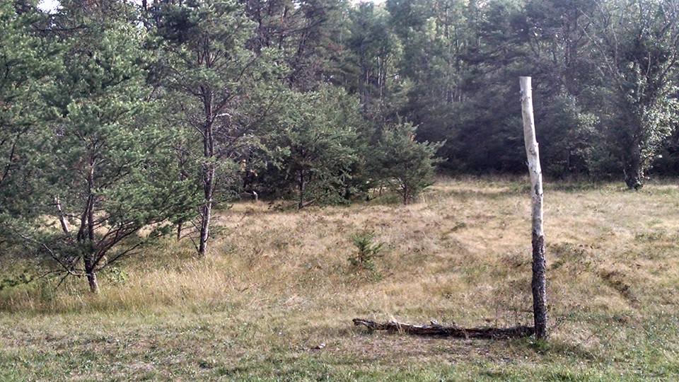
Star City is west of Houghton Lake on M-55, about 5 miles.  Turning north on Star City Road, the cemetery is on the left, and the one remaining structure, an old school building, is a bit further down on the right.  The school building is located on private property, so we were only able to photograph it from the road without exploring much:

14291755_10210079527522729_3006874558487153600_n

The cemetery is easily accessible, though, and has both Civil War veterans and more recent burials as well.

14232401_10210079527762735_7064639869996168651_n

It’s hard to find much information about Star City’s origins or its demise, other than it was first set up with a post office in 1872 and called “Roy,” and later “Putnam” when the post office changed hands.  Then, in 1885, it was officially named Star City, and the name continued until 1923, when it was disbanded.  There is a story that the entire area was first known as “Starvation Lake,” after a trapper who was found dead in his cabin from apparent starvation.  Whether this is true or not is unable to be verified.

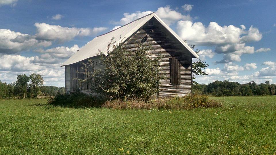
After this, we made our way south of Houghton Lake to the real, actual Podunk,  MI.  Located on the corner of Ziemer Rd. and Shearer Rd. off of M-18 in Gladwin County.  There’s even a sign!

14291889_10210079526362700_8798281830905290994_n

All that’s left here is an old school house in the middle of a field, and a former church that’s now a private residence (to protect their privacy, we didn’t photograph it–plus, it really doesn’t resemble a church so much anymore).

14344814_10210079526762710_7868264590444965841_n

Almost nothing is known about Podunk–its inception or its end.  The thought is that it may have started as a lumbering community, turned to farming, and then just petered out over time.  Some online commentators have said there used to be a dance hall in town for entertainment, but that’s about all there is to know!  There’s no cemetery attached to the community that we could find.

Adventure #1: Pere Cheney

Our adventures actually began last year (only this year did we decide that maybe, since we seem to be making a habit of this, we should blog it for others to read about) on September 9, 2016.  It happened a bit by accident; Issa, Sara, and Issa’s mom were heading up to Mackinac Island to participate in the annual run/walk around the island and stopped in Grayling for some delightful desserts from Goodale’s bakery.  Sara knew the area from years of camping there with her family, and is acquainted with the owners of the bakery.  Issa was idly checking Google Maps to see where they were and how far they had yet to travel, and noticed Pere Cheney on the map.  This was surprising, given that she’d just recently read about it in a news article discussing Michigan’s ghost towns.  Why would a ghost town still be on the map?

We never did get a satisfactory answer to that question, but our curiosity was piqued and we headed out to find it.

Pere Cheney is 2 miles east and 3-4 miles south of the Grayling exit off I-75.  It’s actually easiest to get off on exit 251, which is 4 Mile Road (south of Grayling) and then following Beasley Ave. and E. Railroad Trail.  It’s easily found by routing it on Google Maps.  Be prepared for a lot of overgrown shrubbery and sandy dirt roads!  It’s very much in the middle of nowhere.  Here’s what we found on the spot:

This slideshow requires JavaScript.

In other words, a whole lot of nothing!

The story we dug up on the town of Pere Cheney can be found more fully on its Wikipedia page, but here’s the gist: it was formed in 1874 as a lumbering town, as so many small towns in northern Michigan were.  It was fully functional: a sawmill, a doctor, a hotel, and a post office, and of course a depot on the Michigan Central Railroad.  At its peak, it was  home to roughly 1,500 people, but two rounds of diptheria in 1893 and 1897 and the decline of the lumber industry left only 18 people left by 1917.  The post office closed in 1912 and the site was officially abandoned by 1917.

There were no structures or foundations left to see; however, a cemetery still exists if you continue to follow the road away from the highway (it’s tricky–there are two roads, one on each side of the railroad tracks.  You want to be on the inner/right-hand side road, which is called Center Plains Trail).  One website claimed the cemetery was derelict; however, we found it to be in decent enough condition.  The grass was well-kept and people were clearly visiting and leaving flowers and tokens.  Unfortunately, there was evidence of headstone vandalism and stones that were outright missing.

14238218_10210079534082893_5786606773388145749_n

Sadly, there are many children buried in this place, and you can easily align their death dates with the diptheria outbreaks in the late 19th century.  Some families lost several children in quick succession.  It’s no wonder they’d feel compelled to leave and start over in a new town after such grief.  It was nice to see people leaving little toys and even a package of fruit snacks at the headstones of the children–we were glad to see they were being remembered, even if they no longer had family nearby.

On a side note, there is a local legend that the town was cursed by a witch, which caused its demise, and that she’s buried in the cemetery.  Others have claimed ghostly occurrences when visiting the cemetery.  None of these were observed by us on our visit, we’re happy to report!